
The Life Cycle of a Typhoon
Author: Abaiter
Everything has a life cycle, and a typhoon is no exception. This article follows a typhoon from birth through growth and maturity to its eventual demise.
The birth of a typhoon
A typhoon is a tropical cyclone that forms in the western North Pacific. Tropical cyclones develop over many of the world’s oceans. Those in the eastern Pacific and North Atlantic are called hurricanes; those in the Indian Ocean and South Pacific, cyclones; and those in the western North Pacific, typhoons. The names differ, but these storms form and function through the same mechanisms and belong to the same class of weather system. So how is a tropical cyclone born?
Over the vast tropical ocean, intense sunlight warms a deep layer of seawater. Water evaporates rapidly from the warm surface, creating a broad expanse of moisture-laden air. Then a disturbance develops in the atmosphere. It may arise from the monsoon, a tropical atmospheric wave, or an upper-level cold-core vortex. Whatever its source, warm, humid air begins flowing toward a common center. The disturbance draws in large volumes of this air, which collect near the center and rise. In the colder air aloft, water vapor condenses into droplets. Condensation releases heat, warming the surrounding air, lowering its density, and helping it rise further. As the updraft strengthens, it draws in still more air from every direction and with it a steady supply of moisture. More vapor condenses and releases more heat, strengthening the updraft again. A positive feedback loop is now in place: condensation strengthens the updraft, the updraft brings in more water vapor, and the added condensation further intensifies the updraft. As the cycle continues, the rising motion grows stronger and more air converges from the surroundings. The Coriolis force sets this converging air into rotation around the center. When the circulation’s maximum sustained wind reaches Beaufort force 8, a tropical storm is born.
The key to a typhoon’s birth, then, is the positive feedback between condensation and rising air, sometimes called the typhoon’s “engine.” That is why typhoons cannot form just anywhere. Land and colder seas do not provide enough water vapor to start the engine, so typhoons generally cannot develop there. Where low-level and upper-level winds differ sharply, they tilt the storm’s vertical structure out of alignment. The engine becomes distorted: condensation aloft can no longer reinforce low-level inflow and ascent effectively, and development stalls. At extremely low latitudes, meanwhile, the Coriolis force is too weak to make converging air rotate. The system remains an ordinary cluster of convective clouds instead of growing into a larger storm.
The growth of a typhoon
A strengthening typhoon passes through several stages. In order of increasing wind speed, China classifies them as tropical storm, severe tropical storm, typhoon, severe typhoon, and super typhoon. The United States uses a similar scale for hurricanes: tropical storm, followed by Categories 1 through 5. The categories differ, but they serve the same purpose. A storm’s classification tells the public how intense it is and helps people prepare, both mentally and materially.
Does every typhoon pass through all these categories and reach the highest one? No. Many remain tropical storms for their entire lives. Some slowly climb to typhoon strength, others steadily intensify into super typhoons, and a few jump several categories to become super typhoons in a single day. Five main factors can either limit or promote intensification.
1. Ocean heat content and sea-surface temperature
The higher the sea-surface temperature and the greater the ocean heat content, the more energy a typhoon can draw from the ocean and the more readily it can strengthen. If the storm lingers in one place long enough to use up the available heat in the water below, it will weaken rapidly.
2. Upper-level outflow
A typhoon lifts low-level air high into the atmosphere, and that air has to go somewhere. It flows outward in every direction. When the surrounding environment supports efficient outflow, air can escape aloft, making room for more warm, humid air to rise and helping the typhoon intensify.
3. Vertical wind shear
Vertical wind shear is the difference between upper-level and lower-level winds mentioned earlier. If the shear is too strong, it separates the upper and lower portions of a typhoon’s circulation. A storm effectively torn in two is unlikely to become very powerful.
4. Moisture
Air flows into a typhoon from every direction at low levels. If the surrounding air is very dry, the storm may run short of moisture. Without enough water vapor to condense and release the heat that powers its engine, the typhoon cannot intensify rapidly.
5. How quickly the circulation consolidates
A developing typhoon sometimes forms with more than one center. If the incipient storm has multiple centers, they must consolidate quickly before the system can become very intense. Otherwise, the competing centers fight among themselves, and the internal conflict keeps the storm as a whole weak. When most of these five conditions are favorable, the storm may develop into a super typhoon and reach full maturity.
The maturity of a typhoon
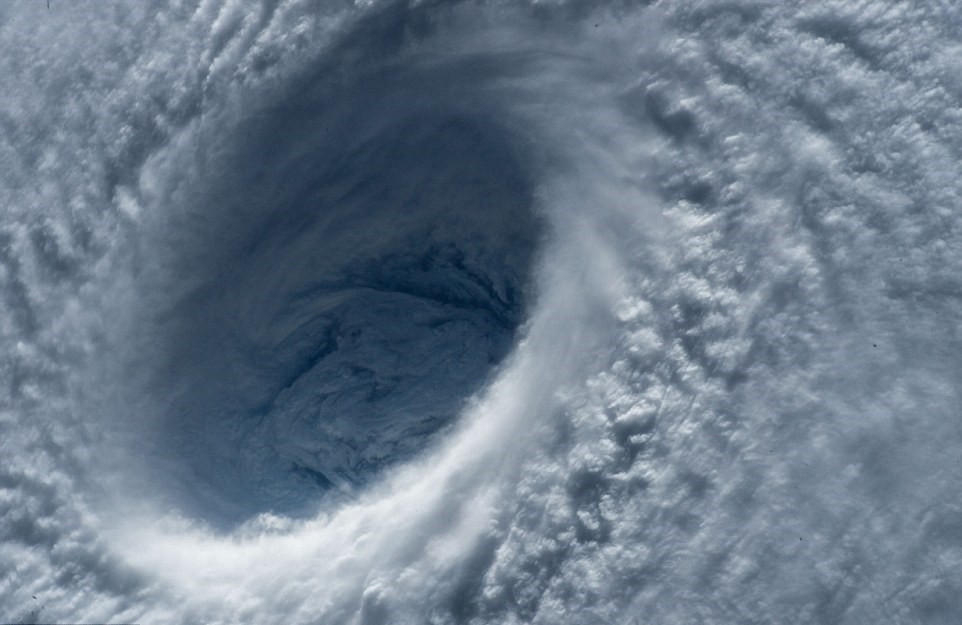
As a typhoon strengthens, the inertial centrifugal force associated with its spiraling circulation gradually pushes convection away from the center. Wind and rain at the center itself weaken, and blue sky and white clouds may even appear. This region of suppressed convection at the center of a powerful typhoon is the eye. From space, it looks like a calm eye surrounded by cloud masses filled with violent wind and rain. The formation of an eye marks a typhoon’s full maturity.
The eye has the lowest air pressure anywhere in the typhoon. Moving outward, the first feature we encounter is the eyewall, a rapidly rotating wall of cloud where the storm’s strongest winds occur. Beyond it lies a roughly circular region of vigorous convection covered by the cloud tops of eyewall cumulonimbus clouds: the central dense overcast (CDO). Farther out, spiral rainbands extend away from the storm, and the wind and rain generally diminish with distance. Along the typhoon’s outermost edge, descending air often brings clear skies and oppressive heat. Chinese meteorologists vividly refer to this typhoon-induced heat as “feeding on subsidence.”
How do we determine a typhoon’s intensity? The Dvorak technique for tropical-cyclone analysis focuses on two main factors: the temperature of the CDO cloud tops and the temperature of the eye. If a sufficiently broad ring of cloud tops reaches an extremely cold enhancement shade, generally below −60°C, while the eye is comparatively warm, generally above 0°C, the typhoon can be considered exceptionally intense.
After reaching maturity, a typhoon often undergoes an eyewall replacement cycle. A mature typhoon acts like an enormous pump, drawing moisture inward from every direction, lifting it through the eyewall, and expelling it aloft. Some moisture, however, rises and triggers strong convection before reaching the eyewall. If this convection forms a ring around the existing eyewall, the typhoon develops concentric eyewalls: a large outer eyewall around a smaller inner one. With the storm’s energy spread more widely, it weakens to some degree. The outer eyewall cuts off the inner eyewall’s moisture supply, and the inner eye gradually disappears. Once only the outer eyewall remains, the typhoon can strengthen again. Not every typhoon completes this cycle successfully; a failed eyewall replacement can prevent the storm from reaching very high intensity.
The demise of a typhoon
Everything that begins must end. So how does a typhoon die?
There is no single answer. Some make landfall and gradually dissipate as friction from the terrain slows them and their moisture supply is cut off. Some enter the midlatitudes and undergo extratropical transition under the influence of fronts. Some fall into a trap of vertical wind shear, are torn apart, and rapidly collapse. Others move over cold water, where their engines sputter and stall.
A typical typhoon has a life cycle of about ten days from formation to dissipation. During those ten days, it gathers energy, displays its power, churns up fierce winds and enormous waves, and finally disappears. Some typhoons live much longer. Typhoon Noru in 2017, for example, was tugged about by other storms and wandered for 28 days before making landfall in Japan and dissipating. Its life took a long and difficult path, full of twists and reversals. Interested readers can watch animations of its cloud patterns and see the force of life embodied in a typhoon.
Some readers may now ask: if a typhoon is a disaster, why describe it with such affection? To call it only a disaster is to see just one side. Typhoons bring both benefits and harm. They cause destructive winds, excessive rainfall, and flooding where they make landfall, but they also help balance Earth’s climate and transport heat and water vapor. Sometimes a violent phenomenon occurs because it prevents something even more violent. A typhoon may look ferocious, yet it helps maintain a deeper balance.
 爱发电(点击图片跳转)